Palmer mines (Fourche a Courtois), Washington County
37.8394° N, 90.9958° W · ± 10 km
Barite from Missouri, United States, with photos of specimens from this locality.
Minerals found here
Barite at Palmer mines (Fourche a Courtois), Washington County
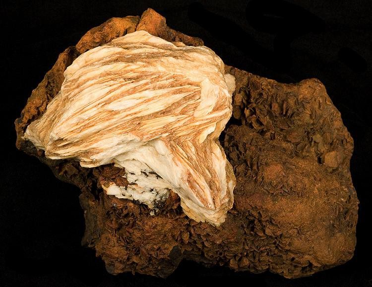
Photo: Robert M. Lavinsky · CC BY-SA 3.0 · Source

- Formula
- BaSO₄
- Morphology
- Rosettes of bladed crystals
- Typical size
- Pictured historic specimen 13.2 x 8.7 x 5.4 cm, larger rosette 8.3 cm across
- Associated minerals
- Gossan matrix (on the pictured specimen)
- History
- Pictured specimen was mined before 1900; Washington County became the leading US barite-producing area, with barite mining beginning around the mid-1800s.
Geology of the locality
- Setting
- Old lead-and-barite mining country of the Washington County barite district; the district's workable barite lies mainly in residual red clay left by weathering of the Potosi and Eminence formations.
- Host rock
- Residual clay over dolomitic limestone (district-level statement)
- Region
- Missouri
- Country
- United States
Coordinates are NOT for the mine itself: they are a point inside the Washington County Barite Mining District (Mindat road-cut record), used to place the district only. Exact mine position not verified. Coordinates: Village of Palmer, Washington County (Wikipedia); the Mining History Association describes the Palmer Mining District as centred on Palmer. Individual Palmer mines along Fourche a Courtois were not located. The workbook value (38.078, -90.741) is about 35 km from Palmer and is not supported. Coordinates: Village of Palmer, Washington County (Wikipedia); the Mining History Association describes the Palmer Mining District as centred on Palmer. Individual Palmer mines along Fourche a Courtois were not located. The workbook value (38.078, -90.741) is about 35 km from Palmer and is not supported. Coordinates: Village of Palmer, Washington County (Wikipedia); the Mining History Association describes the Palmer Mining District as centred on Palmer. Individual Palmer mines along Fourche a Courtois were not located. The workbook value (38.078, -90.741) is about 35 km from Palmer and is not supported.
Sources
- SRC-221 · Article
Barite Mining and Production in Missouri (Miscellaneous Publication 9)Missouri Geological Survey · Missouri Department of Natural Resources - SRC-222 · Database
County Road 361 (State Highway 47) road cut, Washington County Barite Mining District, Missouri (Mindat locality 240511)Mindat contributors · Mindat.org - SRC-314 · Website
Palmer, Missouri - Wikipedia - SRC-215 · Website
File:Baryte-207528.jpg (Wikimedia Commons file page, read via osmand mirror)Lavinsky, R.M. (photographer); Wikimedia Commons contributors · 2010 · Wikimedia Commons

Draft data from the Provenite workbook. Check entries against the cited sources before relying on them. Photos are open-licence images from Wikimedia Commons; the author and licence are given with each photo.